

Friday and Saturday, November 4 – 5, 2011: Grampians National Park, Australia
We began our road trip from Adelaide, in South Australia to Melbourne, Victoria with a 600km drive to the south and east and headed to Grampians National Park. The Grampians is home to dozens of sights, scenic outlooks, bush walks, waterfalls, and reminded us quite a bit of Yosemite. Before we could get here though, we had to check on the progress of reconstruction at the park as a massive flood, mudslides, and landslides had taken a huge toll on the park in January 2011, requiring nearly a year’s work of rebuilding to get things back to some state of normal.
Though there were still a number of road closures due to landslides, boulders, and washouts(more on that later), and about 1/3 of the park is still inaccessible to the public, we concluded that we still had plenty to see and planned on spending the evening and most of the next day at the park.
The 600kms was uneventful. Not boring, but nothing to write home about, either. The radio played music when we could get a signal and the iPod supplemented when we were way out in the sticks. With a couple of stops to stretch and to have lunch, we pulled into Halls Gap, at the eastern entrance of the Grampians shortly before 4:30pm.


Our accommodations for this evening was at a YHA Eco-Hostel. Like other YHA properties we had stayed at previous, the facility was well appointed with communal kitchens, lounges, and clean and comfortable rooms. This facility had an additional bonus as it was designed to provide as minimal an impact on the environment as possible. Solar panels on all of the buildings provided most of the energy, and the bathrooms even took the shower runoff and used it to flush the toilets! Just a few more reasons that we believe that Australia and New Zealand are a step ahead of the curve in taking active steps towards protecting the environment. Everything is recycled here with bins everywhere, from airports to restaurants to parks and gas stations. Toilets even have separate buttons to adjust the amount of water to use. Inspiring to see and hopeful to see more of these ideas become mainstream at home.
We got checked in and reviewed the next day’s itinerary with our hostel hosts, who provided some great recommendations given the detours and continued construction at the park we made our dinner and enjoyed the sunset, with a goal of being awake at first light to head out to the park and to get in some hikes before the weather got too warm.
The next morning, around 6:30am, we were in the car to begin the “scenic route” to our destinations within the Grampians. You see, Halls Gap, where we were staying is only about 5kms from the east entrance to the park. Unfortunately, the flood and massive landslides took out most of this critical segment of cliff hugging, switchback road and it would still be another few weeks until it would be re-opened to the public after months of rebuild. (Pictures in the town center of the flood and its aftermath showed mass devastation to the point that we were surprised that they had made the progress that they had to this point!) This left us needing to take a detour 20kms to the north (on a gravel, unsealed road), 20kms to the west, and finally 20kms to the south to reach the other side of critical segment of road.


Though a substantial extra amount of driving was required, we were treated to unexpected treasures along the way. As we were working our way north on Mt. Zero Road (the 20km gravel, unsealed road), we were constantly on the lookout for kangaroos and wallabies. They were everywhere, crossing the road in the early morning sun, and we needed to be constantly on the lookout for them as we drove, but it let us see nearly 50 of them before this single stretch of drive had been completed! As we transitioned west on the next 20km detour, we were back on pavement, and got to see an area of the park we had not intended on seeing, and in the final 20kms south, we basically had this area of the park to ourselves as it was one way in, one way out, and camping had been severely restricted due to reconstruction efforts. Ironically, after all of that driving for the detour, our destination was less than 3 miles from where we had stayed the night previous.
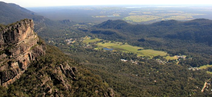
Our first stop was at the very end of the one and only road in this part of the park — Sundial car park. One might wonder why anyone would take a 60km detour to get so deep into a national park that essentially was a dead end. The answer and a well deserved reward lay 2 1/2 kms away on a bush walk that we started shortly after 8am. The bush walk path had been well restored for visitors and we slowly worked our way through the bush, up the hills, over rocks, and towards the summit of The Pinnacle. The grand finale of the Pinnacle is a steel reinforced staircase at the top of a jagged rock peak, overlooking a huge river valley, providing one of the most jaw-dropping views we have ever seen. A 270 degree vantage point on the edge of a sheer 1000+ foot drop, it was a not only a great place to be, but an accomplishment to be shared with no one else in that moment as we had the Pinnacle entirely to ourselves.
After spending some time at the Pinnacle, we began to make our way back to the start as the sun was beginning to turn up the heat and by the time we had returned to the car, around 10:30am, it was already 85 and the temperature was only headed up. From here, we got back into the air-conditioned car, and drove to another five spots nearby — Reeds Lookout, The Balconies, Boroka Lookout, Broken Falls, and Mackenzie Falls. Each provided a new and unique view of this National Park. We finally began to encounter some other people as we slowly worked our way back out of the park on the same path with came in on, realizing that we were no longer alone, but more than willing to share in such a beautiful place — it needs to be shared with everyone that would like to see it, and we’re hopeful that the devastation of the great flood of 2011 is quickly a distant memory.


Winding our way slowly back to our start, we were back in Halls Gap, and we re-entered the park, this time on open roads with no detours and headed south. For the next hour we were treated to scenic vistas and sweeping landscapes as we continued through Grampians towards its southern exit. All along the way, reminders of the flooding and landslide damage were everywhere, but should be overgrown with new plants and trees in no time.
We arrived at the southern gateway for the Grampians in a town called Dunkeld, and within another hour we had arrived at the start of the next leg of our road trip to Melbourne… The Great Ocean Road.
Leave a reply